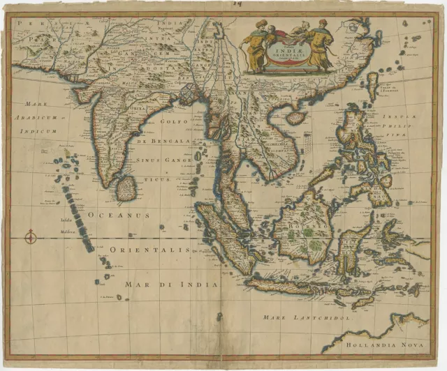
Antique Map of the East Indies by Wells (1712)
| See our ratings Add this shop to my favorites | ||
Antique Map of the East Indies by Wells (1712) $ 1,765.34 Availability: in stock Condition : Good, general age-related toning. Minor wear, small defects outside image. Blank verso, please study image carefully. Date : 1712 Overall size : 57 x 44 cm. Image size : 48 x 35.5 cm. Description: Antique map titled 'A New Map of the East Indies'. Old map covering all of Southeast Asia from Persia to the Timor Island, inclusive of the modern day nations of India, Ceylon, Thailand, Burma (Myanmar), Malaysia, Cambodia, Vietnam, Laos, Indonesia, Borneo, and the Philippines. Based on Nicholas De Fer's map of Asia, the map renders the region in detail offering both topographical and political information with mountains beautifully rendered in profile. The Island of Singapore is shown but not labeled. Bali (Baly) and Lombok (Lombock) as well as Batavia are identified. Most of the Great Sunda Islands as well as the Lesser Sunda Islands, which were largely unexplored well into the 19th century, are mapped speculatively. Depicts a fairly narrow India and a misshaped Taiwan. This map originates from 'A New Sett of Maps both of Ancient and Present Geography' by E. Wells. Artists and Engravers: Edward Wells (1667 - 1727) was an English mathematician, geographer, and classical scholar based at Christ Church College, Oxford. Well's was trained for the ministry but quickly found himself unsuited to religious life and instead applied for an academic position at Oxford, where he authored numerous well respected works on a wide range of mathematical and scientific topics. He was chosen to tutor the young Prince William, the sickly son of Queen Anne. The two must have been quite close for Well's dedicated nearly all of the maps in his most important atlas, A New Sett of Maps both of Ancient and Present Geography. Sadly, he young prince died in July of 1700 shortly before the atlas was published. Nonetheless, Wells' geography proved popular and was published in number editions well into the 1730s. | ||
- Date Range: 1712
- Format: 57 x 44 cm.
PicClick Insights - Antique Map of the East Indies by Wells (1712) PicClick Exclusive
- Popularity - 4 watchers, 0.0 new watchers per day, 1,559 days for sale on eBay. Very high amount watching. 0 sold, 1 available.
- Best Price -
- Seller - 227+ items sold. 0% negative feedback. Great seller with very good positive feedback and over 50 ratings.
People Also Loved PicClick Exclusive

Antique Map of the East Indies by Wells (1712)
£677.51 Buy It Now 22d 1h
Philippines & East Indies 1836 S.d.u.k. Antique Original Steel Engraved Map
£16.06 0 Bids 5d 19h
Antique East Indies Map Circa 1850’s By George Virtue, Pub. Ivy Lane London.
£7.99 0 Bids 3d 12h
Antique Map of the East Indies by De Wit (1662)
£875.17 Buy It Now 23d 2h
Antique Map of the Dutch East Indies
£172.68 Buy It Now 29d 8h
1882 Wells Map - Oceania Australia New Zealand Hawaii East Indies South Pacific
£24.09£19.27 Buy It Now or Best Offer
Royal Selangor East Indies Pewter Map Plaque, A.D. 1700, Hand Finished, E. Wells
£67.47 Buy It Now or Best Offer
