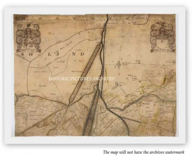
DRAINING THE WATERLOGGED FENS EAST ANGLIA IN 1658 HISTORIC MOUNTED MAP. LISTED HERE A LOCAL HISTORY MOUNTED MAP/PLAN AN SPLENDID REPLICA OF THE ORIGINAL PLAN PRODUCED AND PRINTED TEN YEARS WHEN THE TOPOGRAPHY OF CARTOGRAPHY WAS BEING COMPILED PROFESSIONALLY MOUNTED BUT NOT FRAMED. About the original map. The changing tides of history have brought only one example of a large and impressive 17th-century engraved map safely to the shores of later times. This is one sheet of 16 which were made to celebrate the achievements of an ambitious seven-year engineering project to drain the Fenlands and so turn waterlogged flood-prone land into good farming soil. The National Archives holds the only known copy of the first edition. Why did more copies not survive? The timing of its production, and its distinctive decoration, together told.against it. Around the edge of theoriginal map range 87 coats of arms of investors - 'adventurers' - in a private venture company set up to drain the Fens during the 1650s, when England was ruled by Oliver Cromwell and the Roundheads. Many of these arms-bearers were Parliamentarians and military officers who had served in the New Model Army during the Civil War. The two coats of arms shown are those of the regicide William Goffe and Sir Walter St John. son-in-law of Cromwell's Lord Chief Justice. The decoration thus gave this map a political complexion. This sheet demonstrates how the draining of the Fens physically changed the face of the landscape and the flow of water across it. in accord with the mathematical principles dear to Jonas Moore. the scheme's surveyor and mapmaker. Straight lines provided direct means for water to run, replacing meandering channels. From the top edge where lay The Wash, Downham Eau was cut straight. alongside the winding 'Old Ouse'. Below a complex junction of waterways at Denver lie the parallel Old and New Bedford Rivers. with raised banks to contain floodwaters between them. To left the 'Marshland Cute drove straight across the land. Below it is the 'new-bottomed. Popham's Eau. New sluices, channels and embankments are evident all over this map. The works also changed ownership: this sheet shows some of the new 'lots' given to investors, created from newly drained lands, among existing fields and commons. ; This expensive map would have adorned the walls of the rich and investors in the scheme — precisely the people who needed to prove their loyalty to the King when the monarchy was restored in 1660, two years after the map's publication. A map boldly displaying coats of arms of known Parliamentarians would hardly help their cause. Presumably all copies were destroyed except this one, sent to the Duchy of Lancaster, the area's major landowner. The coats of arms were erased from the printing plates, just as the Commonwealth period was superseded by the Restoration, and the drainage scheme itself had limited longterm success. Yet the quality of the map launched the career of Jonas Moore, who became Surveyor General of the Royal Ordnance, a leading light of the Royal Society, friend of Sir Christopher Wren, and a founder of the Royal Observatory at Greenwich. The map itself was a landmark in large-scale surveys. reprinted with little change for another ISO years — minus those contentious coats of arms. SIZE: 10" x 8" (24 x 19 cm) CONDITION: Excellent condition perfectly preserved in the archives. MOUNTED
PRINTS AND MAPS are identical visually
to a regular paper or photographic image but enhanced with an
extra-rigid backing to provide stability and protection. In short,
the image is mounted onto a substance for ultimate protection against
warping and damaged corners.
The
print is perfect for free-standing display, an album collection, or
framing.
We
do not copy alter or reproduce any of the prints we offer for sale
they are genuine vintage prints of the printing date stated below.
You
may occasionally see a similar item listed, this happens when we
have more than one of the print in the archives.
Some of the text on this map is tiny and needs a good eyesight or even a magnifying glass to read.
I offer a full money back guarantee on my descriptions please bid with confidence
VISIT THE ARCHIVES SHOP TO SEE OTHER HISTORIC PICTURES AND MAPS
Occasionally you may see a similar item re-listed this happens when we have more than one of the item stored in the archives
WORLDWIDE POST Maps Green Archives THANK YOU FOR VISITING


